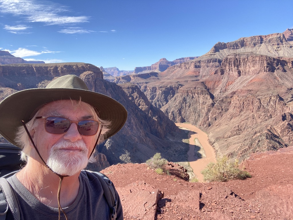
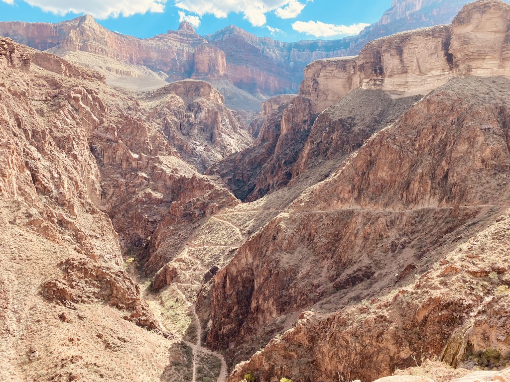
The first order of business was a 1500-foot ascent in the blazing sun to an elevation of 10500 feet. There were the kinds of narrow traverses that allow you about a two-foot-wide trail that consists mostly slippery sand and scree. Lose your footing and you could end up tumbling to your death 1000 feet below. I tried not to look down. After three laborious hours of straining, gasping, cursing and hyper-vigilantly looking up to see if I’m there yet, I arrive at a windy pass. I feed and rest for 20 minutes and then descend 1500 feet into a cool forest of conifers on the other side of the pass.
I found a shady campsite where the wind whispered through the pines next to a flowing stream. I got buck naked, washed off the day’s grime, then fell into a delightful nap stretched out on a rock. 45 minutes later I was startled awake by an earnest looking woman of about 20.
She apologized effusively and humbly asked for my permission to share the site. Of course, she could. It’s not up to me, I don’t own the damn forest. But it is proper etiquette to ask. Props to her. After a delicious meal of freeze-dried macaroni and cheese I pulled out my fiddle and gave it a tickle. I looked up to see a couple of PCT thu-hikers setting up for the night next to us. Kemo, a man in his mid 50s from Lawrence, Kansas and VeeFee a woman in her late 20s from the Czech Republic arrived and set up their separate tents while I played some setup music on my fiddle. We sat down and hung out for a while. VeeFee’s trail name came to her as a result of her pronunciation of the word wi-fi. She had begun her hike at the Mexican border at Campo on the 12th of March. (The current date was the 11th of July). Kemo started in the same place on the 23rd of March. He caught up to her somewhere near Big Bear and they paired up as trail mates. She set up her tent next to his, but I couldn’t clearly tell if they had a romantic relationship or not. We crawled into our separate tents at about 9 PM. I watched a downloaded Netflix series on my phone until I fell into a deep sleep with the rushing stream singing a lullaby. This is the shit. This was why I came out here.
Everyone was packed up and gone by the time I coaxed myself out of the tent the next morning. I never quite get off to an early start. I lingered over breakfast and went back into the tent for a nap because the six days of driving and the timezone change had finally caught up to me. Fatigue had made my mind fog up and I had to do everything slowly so as not to forget things or generally fuck up. It took so long to pack up that, hell, it was lunchtime and so I lingered a little longer. It was 1:30 before I finally headed north on the trail. This was my luxury as I didn’t need to get to Canada or anyplace else. This was the first time that I ambled along a hiking trip without a worry, free from having to get anywhere in particular or race down the trail like it was the Long Island Expressway. I hiked down another 1000 feet into a pleasant, shaded forests of pines and firs, and then up 1000 feet of rocky switchbacks until I came upon some campsites near Boulder Creek. Spaces were filling up quickly with thru hikers who are dropped off at Sonora Pass in large numbers from the Kennedy Meadows North shuttle bus. The bus drops hikers off every day at 9AM, 12PM, and 3PM. This created a thru hiker rush hour three times a day on the trail. I drew water from the Boulder Creek alongside a pretty blonde woman in her 20’s. She asked what my name was. “Fiddlerrick”, I said “what’s yours?” “Trouble” she said. “There’s a lot of people looking for you”, I said. “Everybody tells me that”. Trouble and her twin sister (never learned her name) were cowboy camping (open air) 200 yards down the creek.
In the morning I hiked back to the campsite where I had met Kemo, and VeeFee. Every 3 hours there would come another gaggle of thru hikers from the Kennedy Meadows shuttle. I set up my tent and took another soak in the stream. A couple of thru hikers straggled in at about 7:30 PM. I played the fiddle while a wispy woman in her 20’s named, Sparrow, and a hirsute man about the same age, named Goldilocks set up camp. Three more thru hikers stumbled in after them: Hurricane, Wren and Scarecrow. We had assembled a party complete with fiddle music and craft beer.
After 4 days in the backcountry, I arrived back to my car at Sonora Pass and drove down into sizzling Truckee where I lingered over a hot shower, some non-freeze-dried food, and phone call home to my loving wife.
Donner Pass is unfortunately famous for the tragic Donner party. Their wagon train spanned the North American continent from Independence, MO to Truckee, Ca with much trepidation. They had already crossed the Rockies and most of the Sierras when they got to deep, blue, beautiful Donner Lake and decided to wait for about five days to rest before they took on the task of hauling their wagons over the pass (You can do it now in about 10 minutes in your car). During those five days the the pass became so snowed in that they were stuck waiting at the lake for a long cold winter where many of them died and others resorted to cannibalizing the dead in order to keep from starving to death. This lends a creepiness to the area. It’s helpful if you can tuck that little bit of history in the back of your mind as you hike through this region. It really is a gorgeous place.
Parking at the Donner Pass trailhead was a nightmare. The main lot, small to begin with, was overflowing and cars were parked for half a mile along the road. I hiked an extra ½ mile with a 25-pound rucksack just to get back to the trailhead. There was a reassuring little PCT sign at the beginning of the trail – these signs are not as prevalent as you may think. I imagine they must get stolen a lot.
Going north from the pass, the trail was covered with slippery gravel and loose scree baked in the sun. My least favorite surface. I would rather climb steep rocks then fall on my ass slipping and sliding on this stuff. Nevertheless, I got through that part of the climb and then up over a mountain of maybe 8300 feet. Going downhill on the other side I got closer and closer to interstate 80. The trail actually goes underneath the highway. It’s not natural beauty at its best. You don’t actually stop hearing the highway until you get another 2 miles north and over Castle Peak. From the pass, after a couple of mostly downhill miles, I got to the Peter Grubb hut, built in the 1970s by the Sierra Club. There were signs on the entrances that said the hut was closed due to Covid and they also needed to resolve “other issues”. Since they left the hut wide open, I can only assume this was a sort of double message. What they’re trying to say is you should go ahead and use the hut, no one will bother you about it but if you get hurt or sick or try to sue us … well we hung up the sign and you didn’t leave did you? I opted to set up a tent.
There was a group of about eight fortyish women; all of them moms who managed to escape their parental duties in Sacramento. This was a loud and bawdy girls-night-out-goes-camping crew. I set my tent up on the other side of the hill from them and took a wonderful nap listening to the wind in the trees. In this part of the Sierras there is always a whispering wind through the trees or a rushing stream to lull you into a quiet revery followed by a period of unconsciousness.
Three mountain bikers from the bay area set up a polite distance from me. They invited me over to their campsite for hot chocolate after dinner. While I was savoring a spot of freeze-dried mac and cheese, a pair of thu hikers (Tag and Wonder Woman) set up a polite distance from me and noticed that I had a fiddle. Tag, who came from Hawaii, was carrying a ukulele and wanted to jam.
We started playing and the three mountain bikers came over with their weed. Pretty soon the Sacramento moms came over with folding chairs, booze, and even better weed. Tag and I ended up doing a little impromptu concert for about 12 people who were enraptured by the music. Maybe the weed had something to do with that. And we all watched the sunset over the mountains. It’s the kind of thing that happens on the PCT and makes it special. The beauty of nature, of course, would be enough but then there’s also the beauty of human interaction which can be just as lovely. In what we euphemistically call the civilized world there is so much suspicion, fear and reluctance. Many of us refuse to leave the little bubble that we live in, and our minds are filled with things that we are supposed to be afraid of like people from a different political party, people with a different skin color, the world burning up, and everything just plain going so badly that you want to just sit on your couch and watch the world go to hell from a digital distance.
The news of the day was that there were many forest fires that had been caused by drought, lightning, human error, and climate change. There were indeed large fires and many, many people’s lives were devastated. The part that they don’t tell you on the news is that 99% of the west is not burning. 99% of the time people aren’t getting robbed. There are overwhelming acts of warmth and kindness that take place between human beings every day. There are many decent and lovable human beings that we happily coexist with. It isn’t news if you mow your neighbor’s lawn, but it is news if you burn your neighbor’s lawn. It’s not long before we become afraid that all our neighbors will start burning each other’s lawns. Once you’re caught into the trap you become paralyzed by fear. As someone who spent a few years playing in the New York City subways I can tell you the world isn’t nearly as dangerous as it’s made out to be. And indeed, there are overwhelming acts of kindness, warmth and love every day. I know this might sound naïve but isn’t it equally inaccurate to operate under the assumption that everything is shit.
My next stop was Paradise Lake. It’s a couple of miles off of the PCT. Once you are close to the lake, it is easy to get lost as there are many, many paths that go in every direction. Eventually, I found a beautiful tent site right next to the lake and after a long hard hike I went into the cool water with my clothes and sandals on. It was a welcome relief from the heat and toil of the day. I needed to wash my clothes anyway.
Paradise Lake is way too overused, but I was there on a Sunday night and there were only a couple of groups; one of them was over-the-line loud but I put in some earbuds and ignored them.
There it was, a paradisial setting in Northern California at a time when the rest of the world assumed that this whole section of California is burning to the ground. It was in fact was not burning to the ground although there were fires in the region. The stars were still magnificently clear at night; set in a deep blue sky. Ironically, smoke from the fires to the north and south and east of Paradise Lake were blowing eastward, filling the sky with smoke where I live in Rosendale New York.
On the way back from Paradise Lake, I stayed again at the Grubb hut. There was a young woman sitting up high on a rock, enjoying the late afternoon breeze and trying to get a signal on her phone. She was an ebulliently friendly thru hiker who went by the trail name “Musty”. She had been waiting there most of the day for a male thru hiker whom she swore was not a romantic interest.
This time I got nervy and set myself up a little spot to sleep on the second-floor loft of the hut. The loft was spacious and open with large windows at each end. By the time it got dark, seven people, Including Musty and her friend, were there with me. This was a friendly, playful but well-mannered group of people most of whom had decided to walk from Mexico to Canada, and that sort of person has to be special. I played a little bit of fiddle and sang a little bit of the song “Misty” using the word “Musty”. We joked and laughed, and I felt the wonderful camaraderie and sense of universal love that seems to abound on this fabled trail.
Your average schmo does not pick up and decide to walk 2300 miles from Campo, Mexico to Manning Park, British Columbia. Most people are either too busy or too lazy to do such a thing. Most through hikers are people in their 20s and great physical specimens. They like to sport trademark funny clothes, like American flag shorts or dinosaur hats. The guys all had beards, and the women favored braids. They all had deep tans and a layer of dust over their entire bodies. Those that have been on the trail long enough to get blisters would wear sneakers rather than hiking boots. To keep the dust from caking up on their feet they would attach a kind of low gator with wild looking patterns. These are called Dirty Girls made by a company (owned by two eccentric women) of that name. Many thru hikers, having gone through many experiences of needing three showers to wash their feet, have opted for Dirty Girl protection.
At this point there were two worrisome fires in Tahoe area and another super fire to the north. Sections of the PCT were getting closed off every day. Looking at the Calfire map it was apparent that the coast had no fires at all. After some internet research I could see two possibilities: the first was the Pine Crest trail that climbs up into the dramatic mountains that rise above Big Sur. The second was the Lost Coast trail near Eureka California. I had been Big Sur before and loved it. The idea of climbing way into the mountains far above the swarming tourists on Route 1 was pleasing.
The drive from Truckee to Big Sur lasted about six hours and it was tedious and tiresome. I took interstate 80 which was heavily traveled passing through Sacramento. I’ve heard Sacramento is a beautiful and livable city. This may well be true but my experience from interstate 80 was one of a congested highway, filled with litter and not maintained well by whoever is responsible for that task. There are plenty of aggressive drivers who resemble those that I am familiar with in the New York City area particularly New Jersey.
San Francisco wasn’t that much of a pleasure to drive through either. Again, there were plenty of aggressive drivers and, if you had to pee, there were no rest areas or very few signs indicating the key services available at an exit. This was not California dreaming at its best. California been going through a lot of unpleasant things in the recent past: various surges of Covid, Problems with heat, drought, earthquakes, forest fires, and mudslides when the heavens finally brought rain. There was an ongoing effort to recall Governor Gavin Newsome.
Newsom is a handsome and charismatic man. Once the mayor of San Francisco, his winning smile hinted at his greater ambitions. Ironically, he was married 2001-2006 to Donald Trump Junior‘s girlfriend Kimberly Guilfoyle. You might remember her speech at the 2020 Republican national convention proclaiming “THE BEST IS YET TO COME!! “
There’s been a lot of dissatisfaction in California lately illustrated by a surprising exodus in the last two years to Texas. I don’t know how that works. If I were sick of floods, mudslides, earthquakes and forest fires I still don’t think I’d go to Texas. Obviously, I don’t want to mess with Texas or infer that it lacks coolness. Indeed, Texas has elements of coolness that rival other cool places. A lot of Californians are moving to Austin. Little artistic communities like the one founded by Donald Judd in Marfa are also oaises of coolness. Ornette Coleman and Willie Nelson come from Texas. Both unquestionably cool individuals. Still, there’s a lot to be said for California. I write this laying in my tent in the midst of a redwood forest next to rushing stream and feeling no interest in going to Texas.
There was no permit required for the Pine Crest Trail in the Ventana wilderness. Parking for four days however, ended up costing $40. The hills in the Ventana wilderness are a lot steeper and more hazardous than you might think. Often there are narrow traverses where a wrong step could send you tumbling down a ravine to severe injury or possibly death. The odds are always stacked in your favor if you take care. Most of the trail is in good shape with some spots a little washed out and others strewn with slippery rock scree. The mountain flora reminded me of the kind that grows on the steep hillsides that rise above the sea on the other side of the Pacific in Japan or Southeast Asia. It seems like the same flora although I don’t know for sure how much commonality there is between the east shore of the Pacific rim and the west one.

Throughout the Ventana wilderness there are campsites next to rushing streams of cool clear water. On my first night in the wilderness, I camped in complete solitude with only a few passersby. Despite the vulnerability of sleeping in the deep forest alone, it is easy to slip into a revery in this kind of place.
I used the site as a basecamp and took a lighter pack with me to explore the higher reaches of the trail, leaving anything unnecessary behind. The trail climbed and climbed and then dived down deeply into a ravine. Then climb, and climb up to a traverse and then dip, once again, deeply into a ravine, and then climb and climb to another hilltop. Eventually an ambitious hiker will encounter Sykes hot springs where you can strip down and take a soak in soft, warm water. It’s refreshing and most hikers in the area dash towards the Springs paying attention to the little else. In general, there is a tendency amongst hikers to race nature rather than embrace it. When I was younger and more able, I too was more inclined to race down the trail. At this point, having accomplished many grand things in the mountains and well into my 60s, I choose to embrace the trail at a slower pace, but my pleasure is greater. In my late 60s I’ve become softer and more easily touched by flowers and babies and dogs.
There are mountains in this part of the wilderness that actually rise above the tree line and resemble the hard, gray, granite hills in the Sierras. It was Saturday on my second day there. Hordes of people headed up and down the trail; most of them making a quick beeline to the Hot Springs. The numerous campsites along the trail were full including the one I had to myself night before. When I got back from my walk to the Hot Springs there were people getting a little testy about choice and control of campsites. I was happy to have set up the day before and established myself at what I considered the best site.
A boy, about eight years old, began to walk like a balance artist across a large tree trunk that extended high above the river. It looked dangerous for a kid that age. If he was my kid, I would have discouraged him. But his parents cheered him on and gave him advice on what would be the best technique. They assured me that their child usually made good decisions. Hmm. Who was I to interfere? I left it in their hands. As it was, the cheeky monkey made it all the way across, although he had to finish on his hands and knees. If that were my kid, I would’ve been shitting my pants.
On my second day in the Ventana Wilderness, I climbed about 1200 feet up to the Big Sur Crest Road. I fully expected to end up on some ugly looking dirt road. But, instead I arrived in nirvana. There were beautiful rolling hills of California yellow grass, Monterey pine, and blue gum eucalyptus. Below you could see the vastness of the Pacific Ocean. At least in theory you could, for what I saw was the vastness of the marine layer. That is, the clouds that hang the ocean and hopefully lift as the temperature rises during the day. From the top of this crest, it looked like the clouds you see below when you’re riding in an airplane. It was ethereal; almost like looking down from the rim of Kilimanjaro and seeing similar clouds that, later in the day, will possibly lift enough so that you can see the yellow grass of the Serengeti.
There was a new family that moved into the campsite right next to me and though it was scary sleeping here alone the night before in the vast wilderness I look back upon the experience with a sudden fondness. These new neighbors remind me of the Flintstones. Yabadabadoo!!.
The air is dry, and the temperature is absolutely perfect for human habitation. The sun in California is brilliant and burns deep into the skin if you aren’t careful to wear sunblock. Climbing up the switchbacks toward the ridge today was perfectly pleasant until the trees give way to open spaces higher up the mountain. The sun is so intense that, even when the temperature is only 70° the uphill climb makes it feel like 90°. I saw quite a bit of animal scat along the trail that looked like it came from a coyote or maybe a mountain lion. I’m afraid I haven’t studied scat the way I should have. I would have worried more if I had known for sure.
REI should be grateful for the people that come here. All of them are wearing and carrying highly expensive outdoor gear. They are almost all white. So far on this trip I have seen one black person near Tahoe on the PCT. An expedition of about 12 Chinese hikers came though the campsite earlier today. They were loud and chatty, and it was good to see new people drinking in the beauty of nature. Many folks who have grown up in an urban environment are unfamiliar and perhaps even uncomfortable in the backcountry. City dwellers are known to enter the woods with a dread fear bears, snakes and insects. Conversely suburbanites enter an urban environment and fear random violence, robbery and sexual assault. This is just another way in which we are unfortunately separated into tidy little groups.
At dusk last night I heard young man with an overloaded backpack stumble into the camp site. He, no doubt, had to set up camp and make dinner in the dark. Many hikers delude themselves into thinking they will cover more miles than they actually end up covering. I met him the next morning. He stopped by and we talked for a long time. He seemed to be in no hurry at all and clearly liked to savor the simple pleasure of human conversation. He saw my fiddle there, so I played a few tunes, and he was suitably exuberant. He’d grown up in St. Louis Obispo and just recently graduated from a Catholic seminary. He was a newly ordained priest in the town just north of where he grew up. We chatted for a while and then went about our separate business. As I was packing up my campsite I looked over and saw him reciting mass over a small portable altar complete with candles that stood grandly golden holders. He had donned a white robe and was waving a silk cloth about. Evidently, according to my wife, priests have to say mass every day. And so there he was for at least half an hour with his candles and his white robe in the cathedral of the redwood forest.
I packed up and hoisted my 25-pound rucksack beginning an 1800 foot, mile and a half ascent. I stopped to take drinks quite often and paced myself carefully. The Nepalis say, “Bistari, Bistari”, the Africans say, “Polé, Polé”, and the South Americans say, “Despacio.” Slow and steady will make the climb happier and healthier. I thought of Russell Banks and his article titled “Old Goat or Old Fool “. Pacing myself properly I was able to get to the top of the hill in the blazing sun without fainting or having a stroke. The marine layer crawled halfway up the hill but still you could see down from this perch of about 2800 feet into a cloud covered blanket over the Pacific Ocean. I walk down the road. Down, down, down past a limited number of exclusive, “hedgefundy” houses. The dusty, dirt road was well-maintained. It took me about two hours to get to the bottom where I strode past a Tesla country club, supercharger resort; a curious place full of not-my-crowd rich people. Then onto US 1 where I had to walk another 2 miles on baking tarmac to the Big Sur ranger station where my car was parked. Fortunately, on the way there was an old fashion quaint-looking gas station/store/restaurant where I could stop and get a soda and a celebratory Reese’s peanut butter cup.
Arriving at the parking lot, I fell into a conversation with a man about my age who held forth, without pause, for what seemed like a long time, about his equipment and his orthopedic problems. Recovering from a hip replacement he was grateful that he could still walk 5 miles. I told him that he should be grateful to just put 1 foot in front of the other. I too am grateful.
I drove north to Piedmont, California to visit a cousin who is two years older than me, and I haven’t seen since the 1960s. She was fun to hang out with back then and she still is. She’s gone through a couple of husbands but has lived in the same house for about 40 years where she runs a daycare center for kids between between the ages of one and four. Every day at nine o’clock her house fills up with little schnookums. I had a great time hanging out and playing the fiddle for them. They particularly liked my imitations of bees and birds.
At night Debbie and I got a good red wine buzz going with one of her employees who hung around. We laughed into the night, laughing and talking about the past, the present and the future. We traded a few deep family secrets. It’s amazing how family bonds can last over decades of absence. We hugged a lot.
I pointed the Prius north on I-5 from Sacramento not really knowing where I was going to go. I vaguely had the Shasta wilderness in mind. The road from Sacramento to Shasta City is not beautiful. There’s a long sequence of flat farmland that looks like poorly disguised desert. The temperature was hot reaching as high as 108°F. The highway went through 20 or 30 miles of solid burnt forest. It made my heart sick. The Douglas firs, spruces, and lodgepole pines were all reduced to black sticks jutting up from charred earth. That summer of 2021 was the driest in California since 1924, and I hoped that by the end of August the whole place wasn’t burnt to the ground.
I found a free campsite, what they call a dispersed campsite, in the forest at about 7000 feet elevation near the foot of Mount Shasta; a 14,000 foot mountain with an impressive amount of the climb above timberline and frosted with glaciers at the top. You must obtain a Summit permit to climb the mountain, but this involves no more than putting $25 in an envelope including your address, name and a few other pieces of information on there in case someone asks. Nobody asked.
After a quiet, revitalizing night at the dispersed campsite, I took the trail up to the Shasta Alpine Lodge and horse camp and then toward the summit of Mount Shasta. At the parking lot I disembarked the same time as a 60ish couple with California plates. I hardly noticed them at first, but they ended up following me, at a polite distance, up the mountain for the next 2000 feet. There comes a point on Mount Shasta where there’s no longer a discernible trail. You have to go what the people in the west call “crosscountry“. This means there are no longer any cairns or trail markers of any kind. Sometimes there is a discernible track and then it disappears into a rubble of rocks and scree leaving the baffled hiker to scratch their head. The California couple quit at about 8500 feet. And by 9000 feet I had no idea how to proceed. The idea of getting lost way the above tree line, let’s say 14,000 feet, all by my 66-year-old self, seemed foolhardy. I didn’t really want to have to call the rescue chopper (besides, there was no cell signal) at sunset when I didn’t know where the fuck I was. The best bet was to saunter back down to the trailhead, get in my car, coast down into town, and have a good lunch, followed by a deep meaningful nap at the dispersed campsite.
The campsite was preciously quiet for about an hour. And then the newcomers started to come in. I could hear, on the other side of the hill, some sort of drum playing a repetitive pattern a lot longer than I thought was musically necessary. But this is after all California. There were small groups of people in their 20s who looked exactly like the hippies I knew at the Cambridge food co-op in the 1970s; complete with the kind of nobler-than-thou arrogance that conservatives like to call wokeness.
I skirted southern Oregon through Ashland and Medford then scurried back across the California border to Crescent City. Crescent City it’s not a posh seaside resort. But it is a place where plain old folks can go to catch a little ocean, eat a little seafood and drink a little craft ale. I settled into cold, damp, seaside clam shack. They told me there was a 55-minute wait for food. There’s been a shortage of low wage help in California in general and so restaurants either limited their capacities or they’d tell you right out front that it’s going to take quite a while to get your food. I told the waitress that it wasn’t a problem. Just keep the craft beer coming. I was sitting along a screened-in bar with a vivacious, fortyish couple. They had moved to Crescent City a few years before looking to escape from a high-pressure, professional life in the San Fernando Valley. They loved to prattle and drink, telling long humorous stories with lots of movement and pantomime. They lifted my mood. I had gone for stretches of time on this trip without talking to much of anyone so the opportunity to just sit around sipping craft beer and having few hoots was welcome. I ordered a poor boy on sourdough bread with blackened, seared shrimp, a little bit of lettuce and some chipotle sauce for zing.
Glowing from a craft beer buzz, I went back to the Curly Redwood motel. It was mid 20th century modern that reminded me of the hotel my parents managed, and we resided in, when I was a kid between the ages of two and six. This place looked as if it kept the same furniture since the 1960s and was otherwise never remodeled. It was rough around the edges but still oozing with charm. It had solid red wood siding on the outside and redwood wall paneling on the inside.
I sped down the 101 in my trusty Prius to Arcata then Eureka and then over the mountains to the Lost Coast. You had to twist and wind endlessly on narrow roads lined with redwoods, going no faster than 25mph until you finally arrived at the coast about an hour away from the 101 turnoff.
I started from the parking lot in Shelter Cove. There were no signs whatsoever for the trail. You simply go down to the beach and start walking. This was disconcerting, like a formula for disaster. It was laborious to walk through the loose, black sand with a 30-pound backpack. After two miles there was still not a single sign for the Lost Coast Trail. This even though I had to register online and pay a fee to hike the trail. To avoid overcrowding they only allow 60 hikers per day to register, and I was lucky enough to find a cancellation. It would’ve been nice if they’d been a little more welcoming. Thankfully I had a Guthook GPS guide app for the trail, so I knew where the tent sites and water sources were. I hadn’t realized, from what I had read, that the entire walk was on the beach. For my money that’s just as hard as walking uphill with the big bag.
I started out in a pissy mood. But by the time I walked a few miles on the beach and found a campsite next to a creek that ran down onto the beach I was starting to feel like, “OK this is pretty cool.” And so, it was. I had never before slept in a tent on a beach, and I started to really enjoy the scent of the sea and the rhythm of the surf.
The next part was more harrowing. The terrain was never easy. This is not like your standard walk on the beach hand-in-hand-along-the-sand, casual kind of thing. This is uneven surfaces, large areas of slippery rock scree, fluctuating tides, and a constant search for firm ground to walk on. Walking with a heavy pack through deep sand is no doubt good exercise if you are training or conditioning yourself for something. But that’s not what I was looking for here. There was a four-mile stretch that is impossible to traverse during high tide and so you have to coordinate the hike through that section with the tide tables. The tide needs to be at least a couple of hours into the ebb otherwise you risk being pinned to some rocks for several hours, trying to avoid being pounded by the savage sea.

Looking up from your struggles however, you will see a breathtaking coastline, with mountains covered in conifers, and cliffs that sharply rise from the Pacific Ocean. When the sun breaks through the marine layer the ocean turns a deep and beautiful blue. When the beach is covered in Marine layer the landscape is dark and melancholy like the shores of western Ireland. I consciously raised my head at regular intervals to take in the magnificence. It was important to concentrate on my footing as it would be very easy to hit the deck with all those rocks and uneven surfaces. It goes without saying that hiking poles are a must. I got to the other side of the impassible-at-high-tide section, defined by an area with a big stream called Flat Creek stream. Here there were a multitude of campsites and you could tell that it had been a busy weekend there with as many as 50 to 100 people camping in a relatively small area. Impressive when you think that the only way to get there is a cross several miles of fairly inhospitable terrain. You’d have to hike at least 10 miles across this rough and rugged beach to get to this location. As a consequence, the people I met there were the kind that I usually like. Call it natural selection. These are interesting and adventurous people with many fascinating things that they can talk about. They are the ones who search beyond everyday life to see what it is that’s over the ridge. I admire any person who has refused to have the imagination and curiosity beaten out of them by the mundane practicalities of life.
After more than 20 miles of walking on this laborious terrain I was shattered. I had to wait out the tide in the morning as did many of my fellow campers at the stream. I took my violin out and played it. I wasn’t sure anybody else could even hear me and I simply enjoyed the daily ritual of playing. For me it’s like a form of prayer. A religious ritual that I perform every day for my own spiritual solace. I looked up and there was a young woman about 20 or so. She gushed, “that was so beautiful” and I thanked her. I saw her and her hiking buddies later as we were walking towards the end point of the trail. She came up to me and said, “there is someone who is not afraid to share their beauty with the world “. I was touched by this. She asked me, as if I was her guru, what are the most important things in life? I told her without hesitation they were truth, beauty, love and nature. She and her friends repeated the four of those words a couple of times so as to remember them I suppose. I felt as if I should baptize them in the ocean. But that would be cold.
I was exhausted, delirious and possibly staggering by the end of the hike. Although, after five minutes in the parking lot changing into some dry clothes and a pair of sandals, I begin to feel that kind of elation one feels after having done something very difficult successfully.
I was bleary-eyed after 23 miles over narrow, winding, mountain roads from Shelter Cove to Highway 101. Compensation for the effort came with the plentitude of gorgeous redwood trees along the way. I headed south on Highway 101, thinking I would drive for an hour or so and find a motel for the night. But curiosity got the better of me and when the road turned on to the northern terminus of California 1. I couldn’t help but want to drive down the fabled and legendary road. To get down to the shore however I had to do the reverse of going from shelter Cove to Highway 101 and then twist and wind over the mountains once again to get down to the shore. This was another agonizing trip where one couldn’t really go faster than 25 miles an hour. When I got down to the shore at the beginning of the Mendocino Coast I was stunned by the beauty of the place. At about 7:30 I arrived Fort Bragg and saw a good-looking restaurant where I stopped and while I was waiting to be seated, I reserved a room on Expedia at what I thought was a local Super 8 hotel. They told me it was 25-minute wait for a table so I put my name down and told them that I would go and check into my motel. Then I opened up my Expedia app once again get directions and it turned out the hotel, I had just confirmed was 55 miles away over another twisted, curvy, no-more-than-25-mile-an-hour road. I couldn’t bare it. Desperately searching the main drag of Fort Bragg, I managed to get the last room, the Jacuzzi suite, at a local motel. It would’ve been pure agony to have to go 55 miles over another curvy highway to get back to Highway 101 where the Super 8 was. I was delirious. I went back to that restaurant had myself some of the best fish tacos of my life, a 24-ounce draft beer and chocolate something or another that was absolutely out of this world. The next morning, I was useless.
Useless or not, I had to drive about 6 hours east again to position myself conveniently to pick up my wife the next day at the Reno airport. Consistent with the usual mismanagement, her flight was delayed one hour, then two, and then three. I was overjoyed to hold her in my arms once again after 4 ½ weeks apart.
Quickly, I whisked her away from the absurdity of Reno back to the sweet bosom of the California Sierras. We were booked for three nights at the century old Granlibakken in Tahoe City. The Granlibakken is like a lot of grand old resorts with glowing reputations. The service was spotty, the menu was limited and overpriced, the was no air-conditioning, the sprawling grounds were homely and non-descript. Since we were both exhausted, we ate at the restaurant on the premises. We were planning to go al fresco but smoke from a wildfire northwest of Tahoe had forced all diners at Granlibakken indoors to what looked like a function room. We had a salad, two burgers, and four glasses of wine. The bill was $140. They even tried to pad it by charging us for an extra wine. We able to knock it down to $120 - big whoop. Needless to say, we ate in town the next two nights.
Tahoe is known for its cool dry air, deep blue lake, and clear views of the surrounding mountains. None of that was evident over the next two days. California was raging with one of the worst forest fire seasons ever. I hadn’t rained a drop during the month I had been there and all it took was the smallest spark to set thousand of acres ablaze. We were downwind of the Dixie fire which ended burning over a million acres in Plumas, Butte, Lassen and Alpine counties.
We took a drive and hike near Emerald Bay which on another day would be drop-dead beautiful but on that day was obscured by copious clouds of smoke. My throat was scratchy, and my eyes were bloodshot from irritation. We spent the rest of that day and evening indoors doing our best to escape the unhealthy air. By the next morning things had cleared enough for us to go for a hike on the PCT near Donner Pass. We were still a long way from golden sun and robin’s egg sky by we were too restless to stay indoors for yet another day.
As the reader might recall, the last time I had been to Donner Pass I was forced to park a ½ mile from the trailhead due to the overcrowded parking lot. This time there were only a ½ dozen cars in the lot. Despite all these distractions we managed to enjoy ourselves and by the end of our hike we had agreed to backpack into the Peter Grubb hut on the PCT a few miles north of I-80.
The next day, outfitted with full backcountry gear, we climbed up to Castle Pass 8400 ft., the last major pass on the PCT. This is a speed bump compared to the fabled passes (Forester, Muir, etc.) of the high Sierra but it’s still a pretty good workout with a 30-pound pack.
Unlike the last two times I visited the Grubb hut, there was no one else there. We had the entire area to ourselves. We set up my new MSR Hubba-Hubba tent. It’s supposed to be a 2-person tent but you better like the other person an awful lot because it makes for tight quarters. After setting up camp we fell into a peaceful, timeless reverie listening to the wind in the trees and feeling that intense inner quiet that comes when you allow yourself sit still for long enough in the wilds. I wanted my wife Kristina to have a chance at glimpsing the brilliant, dense, endless stars that come out on a clear night in the Sierras. The stellar reception was good until about midnight when another cloud of smoke came in from the Dixie Fire to the west of us.
We hiked out the next morning. It was sad to realize that this marked the beginning of the trip home. I had a month’s worth of extraordinary adventure behind me, but it was time to point the bow east. We stopped by the Donner Kitchen in Truckee and had a breakfast that may have been the best meal that either of us had during the entire trip. In Reno we paused briefly to get lunch and an oil change at the Jiffylube to ensure that we were adequately lubricated for the ride home. I am pleased to announce that they did not try to sell me a new cabin air filter.
We navigated east for several hours through the scorching, smoky desert to the Elko, Neveda where we planned to turn north into Idaho.
Most of the news I’ve heard from Idaho is either about Demi Moore, retired LA cops, or ultra conservative militia crazies. I’m happy to say that I encountered none of the former. Well, Demi Moore might have been fun. I knew that the Rockies were spectacular here and that Lewis and Clark had their difficulties at Lemhi Pass. I hadn’t realized how much I would fall in love with the Salmon River, how it winds its way past pine-studded mountains, old mining towns, and spacious ranches. There is old western charm in the small towns along the river where traces of a pioneering past are apparent throughout.
The main problem with Idaho is that it’s too close to Montana and that’s where the strange forces of wanderlust tugged us next.
I’d visited Montana before; went back country hiking in Glacier National Park and hung out with fresh air hipsters in Whitefish and Missoula. It’s famously big and open. Unfortunately for us it was also plagued with forest fires due to the same drought that had cursed California and Oregon. There were great billows of smoke and flashes of red flame on route 43 near Wise River. Nothing is more dispiriting than driving through a charred forest still smoldering from a recent fire.
We passed through this grim scene on our way to Bozeman where we stayed at the shabbiest Motel 6 either of us had ever seen. The guy at the front desk looked like a tweaker in rehab wearing a Motel 6 t-shirt and baseball cap. He was sickly thin, with battered, ruddy skin and several gaps in his teeth. The motel was surrounded by government housing and social service offices. It had vinyl flooring that was cold on the feet. The inside of the room door was bashed with cracks and gouges from a blunt instrument making it look like someone was desperately trying to escape. We escaped to the Walmart across the street to buy food and supplies. There were no live-in-person cashiers and we had to wait 45 minutes in line to use an automated checkout machine. There were about a half dozen long lines like ours, filled with beaten-down, weary looking people who shuffled their feet slowly forward and passively accepted their fate. Between the forest fires, Motel 6, and Walmart concentration camp we had reached an emotional abyss. Kristina got the creeps from the motel and hardly slept a wink.
We went for a 5-mile hike on the outskirts of Bozeman which led us to an overlook with a vast panorama of the city and the surrounding mountains. It was a nice 2 ½ hour hike although some of the route skirted past high-end housing developments that I referred to as, “MacRansions”.
We were booked for one night at a hot springs campground just south of town. Ten seconds after we pulled in the parking lot we decided not to stay. It just wasn’t us. Too much gray concrete, too many RVs, and just way too KOA. We are the wooded tent site kind of folks and not power/water/sewer hookup people. It was mid afternoon and we still had time to kick up some dust driving east to Billings where we stayed in an executive room at the Hampton Inn. Down the street from the hotel, we found a surprisingly good pizza place with a wood-fired oven. With the possible exceptions of North Beach and Sausalito in the bay area, the west has a small population of Italians,. Finding good pizza in Billings Montana is like finding an orchid in the desert. What the west may lack in at Italian cuisine they make up for with an abundance of microbreweries and I washed the pizza with a rich, local IPA.
We broke away from the interstate the next day and hopped on US 12 east from Miles City Montana. We immediately noticed the absence of commercial traffic. Conservative states like Idaho and Montana actually allow triple tandem trailer trucks that shake and wobble perilously in the wind. The first 60 miles of US 12 out of Miles City was almost completely devoid of traffic, making it a stress-free alternative to the interstate. The agrarian landscape rolled gently past exposing layers of green and tan crops. It was wide open and endless. We rejoined I-94 west of Bismarck, North Dakota and made it as far as Jamestown before we checked into another Hampton Inn executive room with high ceiling and an enormous bed. I had hoped to spend the night in Fargo. We both loved the Coen brother’s movie of that name with Francis McDormand, William H. Macy and Steve Buscemi. I was crushed after learning that the Paul Bunyan statue wasn’t there and that it was just a prop for the movie
The drive from Jamestown, SD to St. Paul MN takes about 6 hours. By this time, we had past the 100th meridian and were geographically in the east once again. It’s flatter and greener. Humidity and cloudiness return. It’s the beginning of the end but not quite.
We stay in downtown St. Paul at a hotel on 7th St. a few blocks from the Mississippi River. The area, once overrun with homeless encampments and shelters, had recently seen a lot of new development. As a result, there was the now familiar combination of yuppies, panhandlers, and corporate robber barons occupying the same sidewalks.
We had people to visit in St. Paul. Kristina had an old friend from grad school to meet up with and I hung out with a record company guy who was about to put out my latest release on his label.
Philip Blackburn of Neuma Records lived near the 3M corporate headquarters on the eastern edge of town. His house was set back off the road and had a nice view of both Twin cities. His parents were English, and he had a distinct southern English accent despite having spent most of his life in the US. We jumped into his vintage 1980’s Nissan 300ZX and cruised the area in search of some decent Asian food. Once we settled into a fusion restaurant, we had an interesting discussion about music. I had chosen to release my music on his label because Philip had a vital passion for new music, and I needed someone with a ready understanding of the audience that had to be reached. Back at his place, he took some still photographs and a video to help promote the new release. We also taped an improvisation, just for the heck of it.
We had dinner that night with Kristina’s grad school friend and her husband. They were politically progressive but nevertheless bemoaned the unfortunate move toward strict political correctness in the movement. It’s getting more and more difficult in the current illiberal atmosphere to open your mouth without offending someone. Agreed, it’s important to be respectful but there is no benefit from stifling honest and open discourse. We had an extraordinary meal that could easily have been prepared by a celebrity chef and then took a long evening walk down to the Mississippi.
I had promised my Aunt Penny that we would visit her in Chicago on our way back from the west coast. This is a labor of love insofar as Chicago is a major buzzkill to drive around in. Penny is my mother’s younger sister and though I knew herwell in the 1960’s and 70’s, we hadn’t seen each other since then. We met at yet another Asian Fusion restaurant in Roselle in the western suburbs. I had hoped that Penny would be joined by my cousin Diana who I had also not seen in something like 50 years. Sadly, she was caught up at work and couldn’t make it to the restaurant on time.
Penny lived with my family in Litchfield, Connecticut when she, as a single parent, gave birth to Diana. As a result I got to watch Diana grow up for the first couple of years after she was born. Like the naughty adolescent that I was, I even taught her how to say “shit” which she picked up right away and wandered around the house repeating over and over. Penny had always been fun to hang out with when I was a kid. She tried to convince my mother that she should abandon the strict and abusive child rearing techniques that she employed and rationalize with me more often. This line of discussion pissed my mother off to no end and Penny and I loved to watch her stew. As with my cousin Debbie in Piedmont, CA, it was effortless to pick up where we left off 50 years ago. We had a fabulous night that could easily have gone on for many hours past closing time at the restaurant.
Navigating our way out of Chicago and then Cleveland the next day was stressful and devitalizing. We spent our last night on the road in a Hampton Inn in Erie, PA. I’ve already trashed Pennsylvania earlier in this journal and I don’t want to kick a dead horse, but Erie is unbearably dull. The best place we could find to eat was an Olive Garden. My apologies to Olive Garden devotees but I find highly processed, pre-made Italian food to be offensive. I’ve visited Italy a half dozen times, and the Olive Garden cuisine isn’t nearly as good as the stuff they serve in gas stations in the old country. We fortified the experience with chianti, coffee and dessert to comfort our weary souls. It was the best we could do. We were very brave.
We decided to forgo the rest of Pennsylvania in favor of routes 86 and 17 through the southern tier of New York state. This route is more sparsely traveled than I80 in Pensy and there are far fewer construction delays. Throughout my travels this year I was astonished by how many times the road would narrow down to one lane, traffic would slow to 45 mph for 5-10 miles of orange barriers and at the end there would be a group of guys standing around a truck and a state cop sitting in his cruiser, lights flashing, scrolling through his phone. Despite this perception, the work does seem to get done eventually.
As we get within 50 miles of our home, I start to feel the same sense of pride and relief that I get after a harrowing time in the wilderness. I am relieved to have survived the adventure alive and proud of myself for seeing it through despite the obstacles.
I slept like a baby that first night home in my own bed. There was only a handful of times over the course of the previous 6 weeks that I had slept in the same place two nights in a row.
After a few days of comfort and relaxation in my own home I became keen for another thrill or two on the road. Kristina also reported having a let down after the long journey and spent a week or so in a rueful state, cursing the August heat and humidity. What will come next. There will always be something else in the future. I’m already dreaming about it.
Two Months Later
For many years, in the autumn, and in particular my adult life, I sing Joni Mitchell’s song “The Urge for Going” to myself.
When the leaves we’re tumbling down
and shivering trees lie standing in a naked row
I get the urge to go I get the urge for going
but I never seem to go.
The shackles of adult responsibility required me to bury that urge deep within.
I pulled the blankets to my chin
and bolt my wandering in
But this fall, with the company my wife Kristina, I set off on the road headed West past the blazing autumn leaves of Pennsylvania. (I still don’t like Pennsylvania see previous tirades about road construction in Pennsylvania) but the cozy hills covered with garish colors were beautiful and even more so as we moved into West Virginia.
That autumn of 2021 senator Joe Manchin from West Virginia had become a national, in fact international, focus of controversy for his obstructive strategies regarding the large infrastructure and social services package that the Democrats were trying to pass through Congress while they still held a razor thin majority. You couldn’t help but think of Joe Manchin as you went through West Virginia. His picture was everywhere. He was the last hope for the fading West Virginia coal industry. He was the lone Democrat in the Senate blocking climate change legislation fearing that it would spell the end to coalmining in West Virginia. West Virginians were clearly on his side but the consequences his political maneuvers would be felt by the entire world. Being a pivotal person in terms of majority in the Senate, he had to be reckoned with. There were signs and ads everywhere supporting Manchin and his strategy to save coal mining in West Virginia.
But I didn’t really go to West Virginia to start whining about Joe Manchin, I went there with my wife to enjoy the mountains, foliage, fresh air and the feeling that we had put some distance between ourselves and our home in New York State.
We stopped in Bridgeport, WV a little bit South of Morgantown and stayed at the first of many Hampton Inns and ate at the Bob Evans across the street. My wife had never been to a Bob Evans. She hadn’t missed much but it was solid, B-flat family food at a time when we didn’t feel like getting back in the car and foraging around Bridgeport WV for food. So, Bob Evans it was. They hardly had a speck of vegetarian food and I settled for an omelet. Such is the fate of a vegetarian on the road. I once spent the summer hiking the GR10 in France and ended up with an omelet for supper on the majority of nights. The wife had Honey butter chicken that came with a biscuit. She didn’t realize that and so she ordered two extra biscuits and it ended up being a 3-biscuit dinner. She tried to press one of her biscuits on me, but I wasn’t having it.
We slept well even though the hotel was maybe 100 feet from highway. It was a classy way to sleep by the side of the road I suppose. We could have stuck our thumbs out the window and hitched ride.
We decided not to go on the Interstate but chose US 50 instead so that we could escape the convoy of 18-wheelers and catch some local charm. US 50 traveled west from Clarksburg to the northwest corner of the state in Parkersburg. I had looked it up online and found a website dedicated to describing the entire length of US 50 which goes from Ocean City, Maryland all the way to Sacramento, California. The description said that we would be going on the “loneliest road in West Virginia”. Hot Dang we thought how could we miss that? The description went on to say that there would be scenes of impoverished West Virginians and the ruins of rusted industry. There would be plenty of discarded appliances in yards and abandoned automobiles. The whole place was like a Walker Evans photograph, so they said. It ended up being a delightful drive through some brightly foliated mountains and that was about it. I think you had to go off US 50 a ways in order to observe any kind of genuine Appalachian poverty. We’re not really into tragedy tourism and so we stayed on the main road.
We did enjoy listening to some gospel music on the radio along with manic, loud preachers who sounded completely incoherent and all the over the place, talking about everything all at once. There’s always an underlying social and political message in listening to these Christian broadcast stations. And I wondered if that’s how Trump managed to win over this population. If they could believe in virgin birth maybe you could sell them anything.
From West Virginia we moved down into Kentucky where the road became more sparsely traveled and things seemed more spread out, wide open and a bit more relaxing. We were both excited to travel through Salt Lick, Kentucky. It makes you want to go up to a salt block in the field and lick it – maybe not. I don’t even know if cows still do that. They could be on low sodium diets by now.
I don’t know how they get anything done in Kentucky. The entire state seems to be soaked in bourbon. At nearly every exit of Interstates 64 and 65 there is a distillery. At the hotel where we were staying in Louisville there was a display of locally distilled bourbons some of which cost as much is $800 a bottle. Who the **** buys bourbon for $800 a bottle. Your brain would have to be pickled in the piss to spend that much money.
We went down to the waterfront and took in the grandeur of the many bridges that cross the wide Ohio River. There’s a long river walk where a hobbling old fellow like me can go for a run. The astonishing thing was there wasn’t another soul down there. Well, let’s not say there wasn’t another soul. There were very few when you consider you’re in a city of a half a million people and this is a beautiful walkway along the river on a nice day in October. Is it that the population is so shit-faced from $800 bourbon that they can’t even go for a walk? I hope not. I did notice a disproportionate number of people you don’t associate with Kentucky parked in cars or walking along the river. People with brown skin or women wearing hijabs. Perhaps this is a place for them to go and shed all self-consciousness since all the white people seem to be in a bourbon-induced stupor.
Our hotel was in an area called Whiskey Rd. where we had an exceptionally good dinner at an Irish pub. Usually Irish pub fair is bland and basic, but I had an extraordinary seafood mac and cheese, and Kristina had a curious kind of quesadilla. She said it, wait for it, “tasted like bourbon.” Sounds legit. Afterward we went back to the hotel where, understandably, I had a glass of bourbon on the rocks, and we shared a lovely á la mode bourbon peach cobbler. Then, appropriately soaked with bourbon, we fell asleep early.
Memphis has storied history of music, cotton and slavery. It’s on the muddy banks of the Mississippi River with several islands and lots of amusements for tourists. What I don’t understand is why there isn’t anybody there. We drove into town on Interstate 40 and got off on North Front St. Like in Louisville, the streets were void of all but few pedestrians. Is this a Covid thing? There were many buildings, shiny new ones, and an impressive skyline but it didn’t seem like there was anybody home. We were creeped out. It seemed like the apocalypse had already arrived and everyone had somehow vaporized. The film I am Legend comes to mind.
I went for a run on the riverfront walk. You would think there’d be all kinds of people out there running and walking their dogs and picnicking with their kids but no. There were a couple of homeless people sitting around with bundles of belongings looking destitute. Maybe one or two other joggers and that was it. I took a long walkway across part of the river to an island that had all kinds of touristy stuff like a museum, swimming pools, a big sign that said “Memphis” and all kinds of walkways and places to run and hang out and it all looked totally cool but there wasn’t anybody there. I had a peaceful but creepy run . We went out in the evening to Beale Street. There’s got to be somebody on Beale Street for God’s sake! There was a couple of folks. But mostly we saw empty Blues joints with live bands and empty barbecue restaurants. We stopped into a place where Kristina had incredible barbecue ribs and I had some credible catfish. We slugged down some great local beer and even went to the gift shop next door to buy some barbeque sauce. That was Beale Street in Memphis on a drizzly Wednesday night. It was like a bomb scare. We went back to our deserted hotel on the waterfront and had dreams of drizzle and wet, empty streets.
We drove from Memphis straight through to Amarillo. Why not. We sped through, what we unfairly imagined to be the blandness and banality of Arkansas and Oklahoma. We had originally planned to stay in Oklahoma City but since we miraculously arrived at 4:00 PM it seemed kind of silly to hitch up the horse so early. The roads were mostly flat except for the western part of Arkansas where we grazed the edge of the Ozark mountains. They provided a bit of relief. The humble rolling hills have beautiful deciduous and coniferous trees to break up the topography of an otherwise featureless drive.
Amarillo itself lies right on the 100th meridian and it is and feels like the beginning of the West. Indeed, right on cue the landscape becomes more arid. Little by little tumbleweeds start to blow across the road and the grass becomes yellow and wispy. The most spectacular thing is the windmills. The windmills light up red at night. They flash in unison; thousands of them that look like a Martian army performing drills in the desert night. We stopped twice to take pictures and marvel at the sight. It was a useful distraction from our fatigue brought on by 607 hundred miles of driving. We needed this side show to carry us into Amarillo.
Amarillo and Interstate 40 in general between Oklahoma City and Amarillo is part of what used to be route 66. Route 66 does not officially exist anymore, however we did pass two different Route 66 museums in the middle of nowhere. When I was about ten years old there was a TV show called “Route 66” the starred two cool detective-looking guys wondering along the famous highway in a Corvette. The storied road was also celebrated in the song “Route 66” written by Bobby Troup and made famous by the Nat Cole trio. The idea of Route 66 causes us to long for the American kitsch of the mid 20th century. The gawdy looking restaurants and hotels, enormous cowboy statues and old gas stations.