Saturday, August 5, 2023

Steaming, Bubbling, Rumbling, and Erupting in Iceland


 7/6/23


If there is another place like Iceland on earth, I am unaware of it. The landscape is made from multiple layers of geothermal and geological disturbances that display a history of raucous events leaving dramatic evidence across the landscape over many millennia. There are jagged mountains that turn a vivid green in the summer. Steam rises from underground, geothermal water sources. Iceland is rumbling, bubbling, and rising. As climate change increases temperatures, the surface of the Earth rebounds upward as the weight of the melting ice decreases. Lava is everywhere. Ancient lava, covered with delicate moss, strewn over millions of square miles; more recent lava flows that look like rivers frozen in time, and red-hot molten lava spewing from active volcanos. Volcanoes are one of the main geographic features of Iceland. Iceland is the home to one-third of the lava that ever flowed on Earth. As much as 25% of the Icelandic land surface is covered with volcanoes. There are 32 volcanic systems comprising 130 different volcanic mountains. All this extraordinary scenery is surrounded by ocean and stark gray sand beaches.
On a lark, I took an opportunity presented by Play airlines (formerly WOW). I’d never heard of them, but they were offering cheap, round-trip fares from Stewart airport in Newburgh, New York (a short drive from where I live) to Reykjavík Iceland. I had always had Iceland in the back of my mind as a place to visit, hiker and nature nut that I am. And so, it came to pass. I boarded an outdated jet with amazingly uncomfortable seats. There are none of those little TV screens on the back of the seat in front of you, no free food, and very few accoutrements. The seats were narrow and crowded. If you wanted a roomer seat you could pay extra (anything from $25 for something just slightly better to $120 for an exit seat, or something in the roomier rows in the front. They charge you for pretty much everything. I had already pre-paid online for my luggage at a rate of $60 each way for 20 kg. I weighed in a 22 kg and right there at the check-in desk the took me for another $40 each way. They charge for carry-on baggage as well. I brought a few items on the plane in a fanny pack to avoid the carry-on fee. 
If you get hungry of thirsty, you must press a button to summon one of the flight attendants, and order something which you will pay dearly for. Even if you just want water, you gotta open that wallet. Fortunately, the toilet paper in the bathroom is free. 
The flight crew were all energetic, pleasant and of Icelandic dissent - possessing unbelievably long names. 
The plane landed at about 4:30 in the morning. It was light like it would be at 10 in the morning this time of year where I live. Iceland in July gets dusk-like between the hours of 1 AM and 3 AM. I brought along some eyeshades to help me sleep.
There’s no way you can check into any hotel in the world at 5 AM in the morning. I booked my room for the night before so when I got to the hotel, I could immediately shower and nap. 
The people from the airport shuttle bus company told me that my hotel was just across the street from the bus terminal in Reykjavík. It was not! In fact, I had to roll my 22 kg Northface expedition bag up and down hills for about 20 minutes until I reached the hotel. The light was so bright that I forgot what time it was. I kept saying to myself “my Reykjavík is such a quiet city.” It took me a while to realize that nobody was awake yet. I stayed at an “art hotel.” There were large, bold, beautiful paintings on display everywhere, and a spacious library with shelves that were lined with ancient volumes as well as modern murder mysteries. Long, leather couches formed squares around low coffee tables. Chess boards were plentiful. Since it was so early in the morning, I could catch a nap for an hour and still take advantage of the complimentary breakfast. After salmon, muesli, and yogurt I walked into the center of town. The hotel was just a couple blocks from a beautiful park with a lake named TjÖrnin SuÖurtjorn.  I walked along until I reached the end, taking a left by the Monument to the Unknown Bureaucrat, past the City Hall bus stop where I would be picked up by the trekking company the next day at 7 AM.
I’ll just say it, Reykjavík is boujee! The downtown is chock-full of cobblestone streets lined with high-end shops selling hats, scarves, sweaters made by local weavers, and pricey, name-brand, outdoor apparel. Copious coffee houses, restaurants were all eagerly seeking top tourist kroner. 
The wind was brisk off the bay, although, to my great surprise, the temperature rose to about 60ºf, and it was unabashedly sunny. I had studied the weather report carefully during the previous couple weeks and it looked dismal with clouds and drizzle. The average daily high was somewhere in the mid 50s and the low was somewhere in the mid 40s. I expected never to see the sun on this trip and yet on the first day I had to buy some cheap sunglasses from a drugstore. Oh, happy tragedy. 
The seashore is rugged and beautiful. There’s a rocky gray beach where people have constructed thousands of clever looking cairns with volcanic rocks. The mountains across the bay are usually covered with snow in the promotional photographs but apparently not in July. 
I walked 4 1/2 miles in and around the city center before I went back to the hotel for another nap (the first one didn’t really do it).  I woke up hungry and began to forage for food. The people who worked in the restaurants and stores and we’re all friendly, polite, and fluent English speakers. I walked up the hill to a towering 244-foot steeple of a church. It’s really a steeple that goes all the way to the ground. Hallgrimskirkja celebrates the High Lutheran sect. The design is stark and spare like the Icelandic landscape. The church is named after the 17th-century clergyman Hallgrímur Pétursson. At the entrance to the church stands an imposing statue of Leif Erikson, whose father, Erik the Red, had much to do with the early settlement of Iceland.


Just about every name in Iceland is long and intriguing. It’s mystifying to hear the locals pronounce them. Even visitors from other Scandinavian countries have difficulty decoding. The Icelandic tongue (íslenska) has so many idiosyncrasies and difficult pronunciations that really no one else, besides the natives can speak it with any credibility. It’s likely that Icelanders speak excellent English because there’s no place in the world, they’re ever going to go where people will understand Icelandic and they’ve come to accept that. 
On my second day in Iceland, I woke early and rolled my 40-pound Northface expedition bag down the hill and past the lake to City Hall where I was whisked away by an Arctic Adventures bus. There were two kinds of people on the bus. There was a day group that would drive four tedious hours out to Landmannalaugar, take a little hike, and hang around the busy campground for about four hours, and then get back on the bus for another four hours of tedious, driving back to Reykjavik. I was in the second group. We would spend two nights in a “hut” where we would sleep in rows, en masse dormitory style. The French call this a dortoir.  I call it a snoretoir because somebody always starts snoring and hell, half the time it’s me. To save the others in the group (there were about 10 of us) I found a private bunk room that was meant for guides, but not being used on that particular night. 
I got a pretty good night’s sleep, even though it never really gets dark in early July. It might get a little dusky at about 2 AM, but that’s it. I went out to relieve a call of nature around midnight, and the Hot Springs about 100 yards away, was packed with people soaking and socializing in animated voices. 
We would spend three days hiking. The first day was beautiful, in terms of the scenery and the weather. It was unabashedly sunny!  We went up and down several significant mountains, and finally arrived at a crater formed by a volcano at some point in the distant past. It was filled with water like a lake with deep purple colors around the edges. The hike was all downhill on the way back but added up to be about 13 or 14 km long. Everybody was “good tired” and just a little bit sore. 


The next two days featured more challenging hikes. The brochure for this trip said the hikes would be easy to moderate. In our group, there were people of a variety of ages and trekking abilities. The second day hike went up and down several, steep, slippery hills. With the additional thrill of a traverse through a snow field. If one were to slip in the wrong place, one could easily fall to one’s death. A 50-year-old woman in our group got to the snow field and freaked out. She froze and couldn’t move. She wanted to call for a helicopter. Thankfully, her family coaxed her gently and she made her way slowly, gingerly through the snow field. This was not a moderate or easy hike. This was strenuous and difficult. An experienced guide probably wouldn’t take a group like ours on a hike like that. On the third day I stayed at the hut because I was nursing a case of plantar fasciitis, and the woman who freaked out on the snow field stayed behind as well. That day I hiked it to a peaceful, beautiful area on my own. I went through a range of volcanic, rhyolite mountains that nature had painted in a variety of vivid colors, and then up a steep path to some places where steam would rise from mud springs or fumaroles. It was a novelty to play around in the steam; not something you run into much of any place else. 


The group would share two meals a day together in the hut dining area. After breakfast in the morning our guides would make sandwiches for lunch. We hearty meals washed down with wine at night. 
Our Slovenian guide was on her maiden voyage in terms of leading 3-day excursions. She was in her mid-20s, energetic, helpful, and pleasant. She seemed unsure of herself in certain ways which gave away the fact that this was her first rodeo. She made several trips to the Ranger station to make sure she had the right directions for the hike. She got a little bit lost on the first day. Everyone has to start somewhere. Maybe after she gets more experience, she’ll develop a keener sense of each group and what kind of hike they should take. 
After we got back to Reykjavík, I rented a car and drove out Route 1 on the southern tier of what they call the “golden circle” that circumnavigates the entire island of Iceland. Many folks who visit Iceland spend a week to ten days driving the length the golden circle. I prefer to spend less time driving and more time walking.
On the subject tourists, it should be noted that Iceland, in general is inundated with them during the summer. People from the sizzling south of Europe in particular, like to get a break from the extreme heat that has plagued them in recent years. At Landmannalaugar there were throngs and throngs of people with backpacks and expensive hiking gear all looking to get a 3-4 hour walk through the beautiful Icelandic interior. There was a full campground next to the hut where we stayed. The hut had at least 40 or 50 other people staying in the other bunk rooms. The parking lot was full and folks just kept showing up. You can’t blame people for loving beauty I suppose. 
On Route 1, in my rented jeep, there were many beautiful places to stop. Like national parks in the US, hundreds and hundreds of people would be parked in a pay lot in order to take in the beautiful sight of a glacier or waterfall. There were inevitably restaurants and hotels that would surround these points of interest. It cost between two and three dollars per squirt to the public bathrooms. It was easy to duck the fee and most people did. 

I stayed in a country guesthouse with beautiful facilities. They were 20k from the nearest town and the only thing the hotel restaurant served for dinner was fish and chips. Out of inertia I opted fror the fish and chips, and hell, it was good. 
I took a walk after dinner down to the sea and got at least 2/3 of the way there before it started raining. This was the first time. Before I got to Iceland, I thought that every day would be in the mid 50s and drizzling. 
The next day, if you can believe it, was even warmer and sunnier than the ones before it. The bright sun brought out the rich verdant green of the moss that grew on the side of the mountains. The immense, brilliant, Myrduls-Jokull glacier capped the high plains. The air was hyper-clear and full of detail; you could see a bug on a rock 100 yards away.  


I walked up a steep hillside to the edge of the glacier. The ice wasn’t pristine, white, or ethereal blue like you might see in an arctic climate. This ice dirty white with a translucent coat of black volcanic dust on it. The island has gone through thousands and thousands of major and minor volcanic incidents over the centuries. History has left a stain on the teeth of each glacier. 


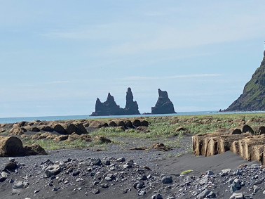
After the Glacier hike, I drove south on Route 1 to the town of Vik. Vik had been the location of a Netflix series I had recently watched called Katla after the kind of wool they make Icelandic sweaters out of. The setting was beautiful, bleak, and quintessentially Icelandic. An icon of the series was three stone spires rising from the sea. In the American west, they would call them hoodoos. I had to go to Vik if we’re no other reason than two photograph, the spires that are burned in my mind after watching this very disturbing and dark series.  


My final destination of the trip, the Blue Lagoon, was not actually far from the airport. The entire drive, westward from Vik, was highlighted by gorgeous green jagged mountains to my right in the endless ocean to my left. After about 3 1/2 hours of driving, I arrived at the Blue Lagoon. It’s a resort that features unique Hot Springs with water that is a milky blue shade is due to its high silica content. The silica forms soft white mud on the bottom of the lake which bathers rub on themselves. The extraordinary amount of salt in the water, makes it very easy to float in. It contained all kinds of other beneficial minerals and left me with a glow that lasted well into the night. I got a series of 3 silica mud face masks from a little stand that you can swim up to. The first mask consists of black mud that you spread on your face and quickly wash it off after three minutes. The second mask is a white paste that supposed to do something cool to your skin. You wear that for about 10 minutes and wash it off. The third mask looks like green pistachio ice cream, looking substance that is intended to rejuvenate your face. My 68 year-old mug course could use all the rejuvenation it can get. 


The Blue Lagoon is adjacent to the Svartsengi Power Station a geothermal power plant, which is in the Svartsengi geothermal field. The world´s first geothermal power plant for electric power generation and hot water production for district heating. The electric power station was built in 1976. The Blue Lagoon is actually fed by the water that has been processed through the plant.
All the rooms at the Blue Lagoon resort were booked so I stayed at the North Light on the other side of the power station. When I first saw the hotel next to the steam plant, I thought for sure the place would stink of sulfur. It did not. Not far from the hotel, about 30 km, was an actively erupting volcano. I found this disconcerting. Local people scoffed at the possibility of a major volcanic eruption, in fact, droves of tourists were driving oof-road vehicles into the hills near the volcano, to get a front row seat on the action.


Wednesday, March 22, 2023

Canary Islands in late January


Seeking an escape from the numbing dreariness of late January 2023, I took a trip to the Canary Islands. I’ve never heard anybody I know talk about them. A lot of folks will guess that they’re somewhere in the South Pacific. In fact, they are just off the coast of Morocco. Americans don’t go there much. As it turns out, the place is swarming with winter vacationers, seeking refuge from the damp, gray climates of Germany, Sweden, Finland, Norway, and northern sections of the UK. The largest island in the chain of seven is Tenerife, where the beach-going party animals coexist with the denizens slower-paced retirement communities. There are boardwalks filled with restaurants, bars, and funky stores where you can buy corny beach stuff. Volleyball in conspicuously played by strapping young men and bikini clad young women. Wake from the ferry to La Gomera Higher up into the mountainous interior however, you will encounter a whole different kind tourist. These are the tree hugging lovers of truth and beauty. The beachfront in Tenerife was just a brief two-day stopover for me, insofar as my main destination was an island just to the west. 

                                                     
 The ferry from Tenerife to La Gomera leaves from an impressive terminal in Los Cristianos where you can catch a boat to La Gomera, La Palma, or El Hierro, the three westernmost islands in the chain. The Fred Olsen Express ferry was a sleek, mid-sized boat that carries cars, bicyclists, and foot passengers. There is a bar onboard where some folks started drinking right from the start of this 8:30 AM departure. The sun was warm, and the sea was a deep blue. La Gomera is characterized by jagged volcanic mountains and gray, rocky coast lines that are pounded by the unfettered sea. La Gomera has a relaxed and wide-open feeling to it. A gentle soul can leave the swarming masses of tourists behind. My fundamental project here is to go on a weeklong trek that circumnavigates the island, lodging each night at “rural hotels” in the quaint villages that populate the hills by the shore. The villages have just the right amount of funkiness, and disrepair for a nonconformist to feel at home. There is also enough low-key sophistication to attract nature-loving visitors around the world. Hundreds of miles of trails go up, down, around, and over the lush green, volcanic peaks. (a welcome sight in late January) I will stay in Hermiqua, Vallehermoso, Chipude, and finally San Sebastian for two nights each. Hermiqua was the first stop on the tour. I stayed in an elegant “rural” hotel that had an outrageous, 3-course, haute cuisine breakfast. Each delicious course was presented by a tuxedoed waiter, who gave a long-winded treatise on the preparation of the food. The chef himself visited every table seeking feedback from the guests. 


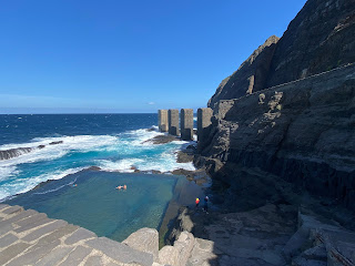
 On the second day in Hermigua I took a long hike though groves of banana trees down to the rugged coast. Most interesting was Pescante de Hermigua were there was ruins from an ancient shipping center and a large, square, cement pool; about 4 feet deep, fed by waters from the wild sea. A few brave souls disrobed and bathed in the salt water. My principal activity there was to gaze out at the endless sea, breathe in the salty air, and feel the warm sun on my face. Pescante de Hermigua 


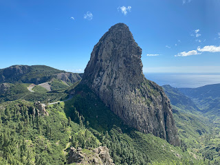
 The next morning, I took the long and arduous hike from Hermigua to Vallehermoso. The trails were strewn with volcanic rock that wears on the bottoms your feet after several hours of walking. It entailed ascending 3000 feet and then descending another 3000 feet. The ascent was a dogged huff and puff, but the views of the mountains, vast ocean, villages on the hillsides, palms, aloe, and the beautiful, green vegetation everywhere was worth it. I continued to be enthralled with the endless expanse of ocean. Try to imagine it. To the west there’s nothing between you and the Caribbean but 3000 of miles of ocean; deep, blue, and mysterious. The descent into Vallehermoso was more of an effort than the ascent from Hermigua had been. I descend carefully. I’ve had a few too many scary slips, in my long career as a hiker. I’ll go slowly if there’s any kind of loose gravel, rock scree, or ice that will make me slip and fall down the side of a mountain or off a steep traverse. There were many steeper-than-I-like switchbacks and lots of wet, muddy rocks. I came upon the enigmatic Roque Cano and traversed around it. Roque Cano The Canary Islands have many of these upright rocks. They look like the heads of religious leaders from the past - like the giant kings of the mountains. 


 The small town of Vallehermoso is, as the name implies, situated in a beautiful valley that leads down to the sea. The hillsides are steep. Brightly colored houses are impossibly perched along the slopes. The downtown has a square and a Spar market. Europe is dotted with Spar markets - as prevalent as Stop and Shops are in America. You can buy all the same stuff at a Spar market. There are the familiar American brands. You’ll have no trouble finding a Coca-Cola or a Snickers bar at these locations. There are myriad varieties of European junk food as well. The Germans call it sheisse essen. European potato chips and cookies that have the same unhealthful caloric content as their American counterparts. It’s the very worst of American culture that catches on the most in the rest of the world. People everywhere have eagerly embraced, junk food, reality TV, over-caffeinated news people, Ziploc bags, and bad rock ‘n’ roll. Nearly every country, no matter how inappropriate, seems to have come up with a version of American Idol. Although there are English-speaking tourists from all over Europe, the locals speak mostly Spanish. A waitress, store clerk, or cab driver is likely to know only a few words of English, and so I am fortunate enough to have learned a few words of Spanish before I got here. Between my lousy Spanish, and their barely existent English we’re able to get business done. The dwellers of the island are consistently cheerful and friendly, always offering a pleasant “hola” to a passing stranger, no matter where they come from. It took a long time to find the hotel where I would be spending the next two nights. It didn’t really show up on Google maps because it doesn’t really exist on a street per se. I had to ask at a bar. The bartender and a few of the patrons went out onto the street with me and pointed their fingers up the hill, “Ahí!” They described how I would have to go slightly up the street from where we were, and then take a sharp right onto an extremely steep pathway, which then turned into an even steeper set of stairs. At the very top of this set of stairs was my hotel, a gated colonial mansion. The owners were surprised that it took such an effort to find the place. I didn’t argue with them. They set me up in a beautiful, two-bedroom apartment, which was way too much for just me. The place was adorned with big arched windows, and high ceilings, although it was freezing cold, and I had to pay for heat. The next day I took a €20 cab ride up into to the steep hills, zigging and zagging on a steep mountain road, going much too fast. I could hardly hold onto my breakfast. At the top of the ridge, we arrived at the Alto Lomo del Flores trailhead where he dropped me. There had been a storm the night before and the first part of the hike was downhill on a wet slate path. I thought for sure I would fall on my tender buttocks, but fortunately did not. If it had been a restroom floor certainly, they would’ve had one of those little yellow warning signs that said, Peligro! piso mojado! The going got tougher as I began to descend steep switchbacks and thrash through what barely passed for a hiking path. It was so grown over in places that I had to use my hiking stick as a machete so as not to become entangled in the thick vegetation that encroached from all sides. The tangled jungle of weeds was wet and with each step I took, my pants and sneakers became more and more drenched, as if I had worn them in a swimming pool. The water in my shoes went squish, squish, squish. Thankfully, the swampy path was only in the low sections of the hike, and eventually led precipitously uphill to Saint Clara from where you can gape at the immense ocean, and the isles of La Frontera and La Palma to the west. Rather than take the squishy path back I opted for a road that took me slowly up another thousand feet. I had to hug the side of the road, which had a railing on one side and a cliff on the other, to let a car pass, or in the worst-case situation, a delivery truck or an RV. The road continued upward and upward. I enjoyed cardiac exercise more than I did slogging through the overgrown, muddy pathways. Eventually the road lead back to the trailhead where I began, and where the taxi had dropped me off. There was a restaurant across the street, and I had the bar keeper call me a cab. I rested there for about 20 minutes enjoying a piece of banana bread and a Coke Zero. Finally, to my amusement, the same cab driver that brought me up up Vallehermoso in the morning had come back up just to pick me up to take me down again. 


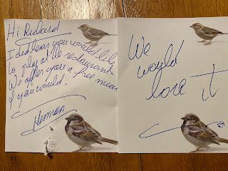
 As with all my past trekking adventures, I brought along an old fiddle in a light case. This was not lost on the hotel owners who left this note in room. The hotel restaurant specialized in vegetarian cuisine made with locally grown ingredients. The food was amazing. A couple of middle-aged Irish guys invited me over to join them at their table. They graciously shared their red wine with me and after a nice meal and a few belts, I took out the fiddle and played a variety of tunes to the loud applause of my fellow diners. Someone asked if I wrote my own music. I played a quiet, pensive invention of my own and, remarkably that is what they connected with them the most. The room was silent, and the crowd was transfixed. I left the place glowing. 

   The trip from Vallehermoso to Chipude is beautiful but strenuous. Basically, it’s a lung-busting, three-hour climb up endless switchbacks until you get to the timeless, old-world, mountaintop village Las Hayas. From there it becomes mostly a downhill climb with some short, uphill sections just to keep it aerobic. It’s only 1.7 km to the next town of El Cercado but you must go deep, deep, down a treacherous path into a verdant, cavernous valley. I reached a point where there was large yellow sign. In bold letters it said, Peligro! (dangerous). Sometime in my mid 60s I gave up on paths that say Peligro! Forgoing the Peligro path meant taking a circuitous route on the narrow-paved road to Chipude. This augmented the length of my trip by at least 3 km. I also had to dodge the buses, taxis, and RVs carrying people who had little interest in hiking this crazy terrain. Most of road was downhill and I was making good time until I got to the foothills of Chipude where I asked an old man sitting on a stone wall how I get to the Hotel Sonia. Excitedly he directed me up a primitive path with stone steps that went upward at a 45° angle. Ahì! he said, in an exasperated voice pointing his finger to the sky. I climbed another 200m upward until I finally got to the Village Square Which was dominated by the hotel Asonia with its restaurant, bar, and modest hotel rooms. 
 My 40-pound, Northface expedition bag was waiting for me in the lobby. There was no elevator and the hotel clerk put the heavy load on his back and strained up the stairs huffing, puffing, moaning, groaning, and looking like he deserved a big tip. The room was about as basic as hotel rooms get. I’m still mystified as to how one opens the sliding door that leads on to the terrace. I’m pretty good at figuring things like that out, and yet I was flummoxed. There was water leaking in the bathroom and I guessed correctly it would continue all night. But still the bed was soft, and there was a portable heater (no extra cost) I could use to dry my clothes and warm the humble space. It. was raw, windy, and raining outside with a temperature of about 50°. In the restaurant I ate a strange kind of potato omelet that I washed down with a half-liter of generic red wine. The next night I ended up having dinner with a fun couple who were 70ish and from Derbyshire in England. We sat up for a long time drinking red wine and then grappa, chatting with increasing excitement about the royal family. After all, I recently became a dual citizen with stake in these matters insofar as I have pledged allegiance to His Majesty the King. The next day I had breakfast with the same couple and continued to enjoy their company immensely. 


With my bags on the way to Saint Sebastian I caught ride to Mirador de Igualero, and hiked up to Monte de Garajonay, highest point of the La Gomera hike. Mirador de Igualero has a chapel that overlooks the sea. The view was obscured by clouds that hung in the high mountains. Ironically the Spanish word mirador means a lookout. Similarly, Alto de Garajonay, a half an hour up the hill and high point on the island of La Gomera, was muddled in mysterious mist. Onward and downward; down steep rocky paths interspersed with steps made from mud and logs. The damp from rain during night before made all this slippery and when it’s slippery I go slow and use my hiking poles (Let me amend that in any event I go slow). Up the muddy steps, down the rocky slopes, up the rocky steps and then down the muddy slopes. In some places the trail ran alongside the road, and you could hear the cars, buses and trucks all speeding along the perilous, curvy road. Unlike curvy roads in South America, Africa, India or Nepal, the roads here are impeccably well-maintained as I have noticed in Corsica. That doesn’t relieve them from the burden of having hairpin turn after hairpin turn as the roads zigzag up and down the steep hills. By the end my feet were sore through the wearing soles of my Inov8 G grip hiking shoes. The last 2 kilometers were thankfully a smooth dirt path except at the very end, just bust my balls, the path went 45° down, down, down ancient steps that reminded me of the slippery stone paths of Nepal. The knee-cracking, steep staircase finally came to an end when it reached the main road. As always, the road itself was the scariest part. My final destination in Degollolada was a gas station/restaurant, what musicians would call a basic B-flat kind of joint. I celebrated the end of the trek sitting in the outdoor café with a Coke Zero and a delicious Snickers bar. I wasn’t sure how I was going to get the next 12k to the city of San Sebastian. It turned out that I was on my own. The trekking company would provide no transportation from the end of the trek in Degollolada to the final hotel in San Sebastian down on the coast. For about a half an hour I sat in the bus stop shelter trying to decipher the bus schedule (in Spanish) and waving desperately at a few of the buses that sped by indifferently. “A la mierda con esto”, I said to nobody in particular, and went back into the B-flat restaurant where I asked the Señora there to call me a taxi. She did so gladly. I told her that she was muy guapa, which she was. She gave me a flirtatious wink to indicate that she appreciated the compliment and no, I wasn’t just some creepy old guy. 
All was forgiven when I got to the hotel Parador in San Sebastian. There, I entered the old-world elegance of the aristocracy. The place oozed charm with old, elegant furniture, beautiful libraries, and dining rooms everywhere. The hallways were filled with ancient paintings and arched passageways. My room at the end of the hall had a massive door that must’ve been 12 feet high and 8 inches thick. The place looked Medieval like a Diego del la Cruz painting. My room was massive with a thick, round dining table, a velvet couch, and a high ceilinged, marble bathroom. There were two huge beds and a patio 20 meters from the sea. That night the wind would whisper through the palms, and I could sit for hours in a blissful reverie. The next morning, I took the ferry back over to Los Cristianos in Tenerife. I stood at the stern of the boat with a small group of passengers. We were all gasping with the delight of watching a small whale frolicking in the boats’ wake. 
A driver from the trekking company held up a handwritten sign with my name on it (I always feel important when they do that) and whisked me up the hill to my hotel in Los Cristianos which was heavily populated with people even older than me. Old men and women with portly bellies and wide hips were all hanging around the pool. Some women were topless but those were mostly under 50. It was a good day to do my laundry. I love the Spanish word for laundry (lavanderia). The washing machines were in the hotel basement. I would leave at intervals and return to my wash every half an hour or so. During one trip down to the basement, I had to stop and let a woman go by. She was looking deep into her phone, and I had no idea whether she would see me, go left, right, or straight into me. At the last minute she looked up and with an English accent she said, “I’m sorry I’m a little drunk.” I said, “Have a good time. “She asked me where I was from then told me she had been a bartender at South St., Seaport, downtown NYC for four years. She asked me if I was divorced, I said no. Did I have a girlfriend? No but I was married. She told me if I wasn’t married, she would be all over me because, “You’re gorgeous.” This doesn’t happen very often, and I’d be lying if I told you I wasn’t flattered. I saw the same woman an hour later leaving with some other guy upstairs in the elevator saying “I’m not sure. Are you sure? “


 The next morning, I dragged my 40-pound, Northface expedition bag uphill for about six blocks to get to the bus station where I could catch public transportation to Vilaflor, a wonderfully rustic town in the middle of the island, on a hillside overlooking the sea. I lugged my 40-pound Northface, expedition bag up one long, steep driveway only to find out from the neighbors that my hotel was in fact on the next long, steep driveway over. So, I towed my 40-pound, Northface expedition bag down the steep driveway, down the steep sidewalk, then up an even steeper driveway to where I finally arrived at the Alta Montaña. It was noon and there wasn’t a soul around. The grounds were elegant like a modern Mediterranean villa. A handwritten sign on the door said that reception was only open from two until five in the afternoon. This left me in a quandary. Should I just sit here twiddling my thumbs for two hours or should I take a chance and leave my 40-pound, Northface expedition bag by the front door and take a walk around town. I left it there. Luckily there was a Cafe down the hill where I refreshed myself with red wine and cookies and then returned to this ghost town of an accommodation, taking a nap and one of the comfortable outdoor couches. At about 1:55 in the afternoon a harried man came to the front door of reception and opened it with his key, said “just a few minutes sir”, then disappeared inside, locking the door behind him. No “come on in, have a cup of tea and I’ll be with you in a minute”. He just walked in the door and locked it from the other side leaving me forlorn and waiting for the clock to strike two. At the top of the hour he opened the door, did my registration, and led me to my room. In most hotels there would be someone to help a 68-year-old man with his bags. This dolt had no intention of doing anything of the sort. He stood at the bottom of the stairs, looking at his watch impatiently, waiting for me to hobble down the stairs with my 40-pound, Northface expedition bag. When it came to cordiality, this place sucked eggs. He dropped me off at the room but didn’t do anything like they do in most hotels, like show you how the lights and TV work or anything cordial like that. He just rushed off and I didn’t see him for the rest of the day. At one point, about an hour later I went to the front desk and rang the bell a couple of times but there was nobody there. I could’ve stolen everything. I wanted to reserve dinner at 7 o’clock in the restaurant. No hope. I left a message on the WhatsApp number that they had posted in the room. No response. Finally, I saw the guy leading some other unwelcome couple to their room and I confronted him. I showed him the WhatsApp messages that I had sent to him. He said, “That’s not my number, that’s the number of the other guy that works there who’s on vacation.” It turned out that he was the chef, and he was trying to do everything while the owner was away. He pointed down the hill and said, “There’s a nice restaurant down there.” I walked down there, and it was closed. Maybe the Alta Montaña should have also closed while the owner was away. 
 
In the morning I had breakfast in the restaurant. It was the typical complimentary breakfast you might get at a highway-exit, Comfort Inn in the Midwest someplace. I managed to find some yogurt and Choco Charms cereal along with a couple of the tiniest muffins you ever saw in your life, and a half-reputable cappuccino. They were not the usual workers there restocking and asking you if everything is OK. There was no smooth jazz or light classical music. It was quiet, like breakfast at a funeral. Everyone, and I mean everyone, spoke German. To their credit, the Germans are pretty good with the English language. They can be taciturn and reserved. However, there are always exceptions. I also met delightful people from Germany along the way who were both gracious, friendly, and even playful. The best way to unfold the mysteries of bus travel in Tenerife is to hold up your phone to the QR code that’s on every bus stop. This will lead you to a website that can give you detailed information, in English, about the bus you need to take and where it stops and goes. There isn’t a city in the world where bus schedules aren’t oblique and obtuse. It becomes even murkier when there is a language barrier. I found exactly the right bus to take me 23 kilometers up steep and winding roads from Vilaflor to the National Parks center. My first ambition of the day was to hike up to the top of Mount Teide. Teide is the 12,000-foot volcano the towers above the island of Tenerife. There was an overwhelming number of tour buses from Santa Cruz and Los Cristianos that brought hordes of tourists up to the national park to walk a half a mile or so, take a bunch of selfies, eat a bit of over-priced lunch, and head back on the bus to their resorts. They dutifully walk the grounds and collect their impressions. The whole video/selfie phenomenon has become international. The smart phone has become another sensor that we have to supplement sight, sound, smell, touch, and taste. We have a new digital sense that takes our impressions and records them in a convenient digital format. That information will be shared on social media. Sometimes I can’t help but wonder if the actual human being ever really showed up. When my bus arrived at the park center, I quickly did my best to separate from the masses. I found the path that led up to the summit of Teide. As with most crowded national parks, you get a mile from the trailhead and there is hardly anybody left to breathe in the solitude. 10 or 15 minutes could pass, and I would not see another human being. The trail winds upward over volcanic rock: sometimes large slabs that you must scramble up and hope that your shoes can grip enough to keep you from slipping. Sometimes the volcanic rocks are small and round like little ball bearings. I slowly made my way up to nearly 9000 feet. Then it began to snow. First there were pretty, little flakes. Then it became steady. The flakes turned into hail. It’s never good to have balls of ice falling onto the trail. The wind started to roar, and the snow/hail came in heavy, horizontal waves. It didn’t take years of mountaineering experience to know that it was time to descend. I gave up all hope of summiting. After all you could take the chairlift up to the top in about 20 minutes, take all your selfies and be with the regular schmoes that go up the easy way. The other thing was that you need a permit (which I didn’t have) to go the last 200 meters to actual cone of the volcano. There’s no big hole there, it’s covered up. You can’t just jump in the hole and offer yourself as a human sacrifice. I went slowly, carefully back down the mountain until I reached flat ground once again. I only had about 40 minutes left before the last bus would head back down to Vilaflor. Just enough time to get a tuna sandwich and a Coke Zero. 


 Adventure and adversity have the same prefix. The adventure is in the adversity. Without mishaps and challenges, I get a little bored. I have a Russian friend who often tells me, “Theese ees not vaction. Vacation ees wodka, cigar, boat, and bikini.” My time in the Canary Islands included plenty of good food, wine, entertaining company, and serene times spent listening to and gazing at the sea. It didn’t rain once, and the daytime high temperature was consistently in the high 60’s and low 70’s. There was always the possibility of having my Russian buddy’s kind of vacation. But that is perhaps for later in life.

Saturday, January 14, 2023

The Grand Canyon: Walking from Rim to River


You cannot see the Grand Canyon in one view, as if it were a changeless spectacle from which a curtain might be lifted, but to see it, you have to toil from month to month through its labyrinths.
John Wesley Powell -Canyons of the Colorado

When John Wesley Powell, one-armed explorer/geologist and his cohort of intrepid crewmen, made their first journey, through the canyons of the Colorado, they were confronted by death-defying rapids, food shortages, tense relationships with indigenous peoples , and such serious infighting that some of Powell’s men deserted him, preferring to take their chances scaling the walls of the canyon, rather than remain under the leadership of a man whose sanity was in doubt. 

Powell and his crew would be incredulous if they could see the Grand Canyon National Park today. They might have pulled out their muskets and confronted the rangers at the gate after being enraged by the exorbitant fees. On the other hand, they might have enjoyed steak and cocktails at the Bright Angel Lodge. They could have replenished supplies at the Market Plaza and then recharged at one of the many upscale hotels.
The park has all the goods, services, and conveniences necessary in a sedentary, high consumption society, abundantly available at opportune points around the rim of the canyon. 4.5 million people visit the National Park each year. You can, if you’re able, walk along the rim on asphalt paved paths and take copious selfies. You can go on a tour with a knowledgeable guide will fill you in on the history of the canyon and even throw a little eco-guilt in for good measure. Then visit one of the shops and get your Grand Canyon, T-shirt, towel, cup, dreamcatcher, and genuine pottery made by the ancestors of ancient Puebloans. All this is graciously provided by private government contractors.

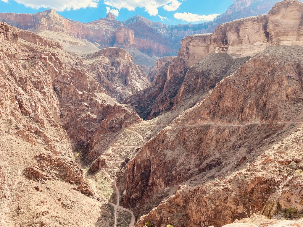
For others, the Grand Canyon is a conquest. During the optimal times of mid spring and mid fall, you can visit the canyon when the temperatures are most favorable to take a longer trek down into the interior of the Canyon. Summer temperatures, even at the rim of the canyon are prohibitively hot and venturing down to the bottom on foot is almost suicidal. The sun can be especially merciless to senior citizens traversing the endless switchbacks that take you from the rim down to the bottom of the canyon where the Colorado River flows. 

“Hiking and mule rides might not be an option if you’re planning a Grand Canyon tour for seniors, but that doesn’t mean you can’t experience the majesty of the inner rim.” – Grand Canyon visitor center web site. https://explorethecanyon.com/grand-canyon-tours-seniors/

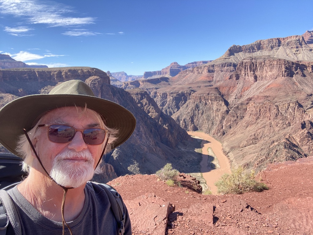
In mid-October of 2022, that I made my own elderly (people over 65 are officially elderly) adventure, hiking to the bottom of the canyon with a full pack, several different kinds of clothing, enough food for a couple of days, Hiking poles, various electronic devices, a miniature gas stove, and Primus cookware. 

I had driven out there from my home in New York State and met up with a friend from grad school in Gallup New Mexico who was on his way back from a backcountry trip in the canyon. He had explored the more obscure regions in the canyon and complained that there was very limited potable water, the daytime temperatures were oppressively hot, and the trails were slippery from loose, dry, dirt, and rock scree. He loaned me a water pump, a ratbag to protect food from rodents, and a detailed National Geographic, trail map.

My pack weighed about 25 pounds, which is much more than most people carry on a day trip down into the canyon. An insignia-blazoned, green-shirted trail volunteer asked me why I was carrying such a big pack? I said, “I like to bring nice China and some stemware in case I have guests.” Spending a few nights at the bottom is a completely different experience from the consumer-oriented experiences around the rim, or the hurried efforts of people who seek to make 10,000 vertical foot, 20-mile round trip up and down the canyon or the 26-mile trip from north rim to south rim in one day. For folks who are fit enough, this instant gratification is preferable insofar as you don’t have mess with camping or obtain an elusive backcountry permit, which sometimes requires applying months in advance. 

My karma must be amazing for I was fortunate enough to successfully walk into the backcountry office and ask them for a permit for the next two nights. The Ranger said that this was “my lucky day.” She told me that this is a miracle unlikely to be repeated for hundreds of years. I don’t think my good looks factored in. She advised me that there were ample water stations along the trail and at the Bright Angel campground. Also, there were locking metal food storage boxes at the campground. I wouldn’t be needing the water filter or the ratbag. She gave me a permit to camp one night and Bright Angel campground along the bottom of the canyon where the Bright Angel creek flows into the Colorado. The second night would be at an oasis midway between the rim and the bottom. Indian Gardens (the proper name is Havasupai Gardens after the indigenous tribe that had been kicked out of there a few decades prior) is a grove of peaceful cottonwood trees that have grown up along the pleasantly flowing Garden Creek. 

There were very few people my age (67) between Havasupai Gardens and Bright Angel. It’s a younger and more athletic crowd. Hiking is like sex: you can do it your whole life if you don’t stop at any point during your middle age years. If not:

Grand Canyon tours for seniors are anything but boring. Enjoy amazing cinematography of one of the United States’ most beautiful destinations, take in the sights on a guided Pink Jeep Tour, or drive your own car deep into the Canyon to learn more about this geological wonder first-hand. Learn more about our tips for making the most of your trip here and turn your upcoming vacation into a once-in-a-lifetime experience.” – Grand Canyon visitor center web site.


Back in my 20s and 30s I imagined 67-year-old people, such as myself at the time, as the ones that you help across the street. The folks who I met on the trail were often amazed to see that I hadn’t dried up and blown away. I ambulated slowly, calmly, and deliberately up and down the steep slopes of the canyon looking like an old prospector with my hiking sticks and a broad, green fedora to shield my head from the baking sun. Many hikers congratulated me on, just making it there and back. They said I was an inspiration and they hoped they were still able to hike when they became hobbling old geezers like me. For them, it’s inspiration for me it’s perspiration. 

I was pursuing a dream that repeated itself every October during the twenty years that I held down a full-time teaching job in Poughkeepsie. When the leaves began to turn I felt this urge, tugging at me during my morning commute. Each day I passed over the New York State Thruway and dreamed of veering off onto the interstate and driving away with no particular ambition or direction, only to follow my dreams. One of my dreams had always been adventure like this to the bottom of the Grand Canyon.

When the sun turns traitor cold
And all trees are shivering in a naked row
I get the urge for going but I never seem to go
-Joni Mitchell

In the interim two days before my permit kicked in, I pitched a tent in the Mather Campground. There was no actual way to get a site on a walk-in basis other than show up at eight in the morning and hope they had some cancellations. With everything booked up so far in advance it was likely that there would be a decent number of cancelations. On that particular morning, about six of us waited in line for 10 minutes and we all rented sites without any further ado.

During the day I hiked halfway down both the Bright Angel, and South Kaibab trails. Bright Angel was 10 miles to the bottom, but it was the less steep than the others. It was also way too crowded. South Kaibab was 7.5 miles long but much steeper and an elderly ortho risk. I decided to go down Bright Angel for the sake of my knees.

I parked my car early in the morning at the backcountry office in Grand Canyon Village and boarded a shuttle bus called the Hiker Xpress. The bus stop was only a mile from the Bright Angel trailhead but, through a feat of the usual mismanagement, they took us first to the South Kaibab trailhead about 5 miles down the road. I had to pee so badly that I decided to just get off there, relieve myself and go down the Kaibab trail – knees be damned.

To prevent erosion, there were logs, 10 inches round and 5 feet long, placed laterally along the trail every 4 feet in the steep sections. This helped to preserve the trail, but it also made it hard to maintain a crisp rhythm. The continual act of walking over the logs added to the muscle fatigue of the descent. There were plenty of other hikers to commiserate with including an impressive number of young, childless couples from Germany and Scandinavia who told me that they preferred to take there holidays in the fall after the crowds had gone and the kids were back in school.


I crossed the Black Bridge into the lush green at the bottom of the Canyon. Riparian vegetation, tamarisk, cottonwood, mule fat, coyote willow, arrowweed, and seep willow were all plentiful. You could easily see the Silver Bridge downriver about a quarter mile. The air was warm with a soft evening breeze. The Bright Angel campground stretched along the Bright Angel creek which provided overnight campers with soothing white noise to sleep next to. The Phantom Ranch was a five-minute walk up the creek. There was lodging, a dinning room, and a snack bar. I needed to quench my thirst after the long hike and setting up camp. They served some of the best lemonade I have ever tasted. I chased it down with a blissfully cold Fat Tire. 

The creek was sonorous and the evening air delicious. I lingered in the gloaming and slept like a baby in my ultra-lite backpacking tent. Even the freeze-dried food wasn’t too bad.

The next morning my calves ached spectacularly. I had a similar experience a few years prior, in Nepal, When I descended 4000 ft. over the course of five miles on the steep stone steps between Gorepani and the bus to Pokara. As before my calves continued ache for several days afterward.

After a luxurious breakfast of freeze-dried granola with milk (better than it sounds) I crossed the Silver Bridge and began to climb uphill on the Bright Angel trail. It’s another 10 miles and 5000 feet to the South Rim but I wasn’t going half that far. I was headed about halfway up the hill to Havasupai Gardens. For years it was called Indian Gardens but just after I visited there The U.S. Board of Geographic Names voted unanimously (19-0) in favor of the formal request submitted on behalf of the Havasupai Tribe to change the name. Earlier this year, the Havasupai Tribe submitted a formal request to the National Park Service to change the name. 


The weather forecast for that night was for violent thunderstorms with wind gusts up to 50 miles-per-hour. Thankfully, all the campsites were covered with ramadas. My tent had two small holes in the top and light rain isn’t a problem, but you’d get soaked in a torrent. The ground was hard as cement, and it was almost impossible to drive a tent stake without completely bending it. Preparing for the worst, I used 10-pound rocks to baton down the corners. The campground was about 80% full. It was only about 100 yards from the Bright Angell trail. For a while I sat and watched the steady stream of down-and-back hikers. A ranger came by to chat, complaining that it looked like a parade. She told me that these caviler speed hikers, and distance runners put a strain on rescue teams that were already overtaxed by foolish mishaps throughout the rest of the park.

I settled into the tent after devouring a gourmet bag of freeze-dried mac and cheese. The wind picked up at about 11PM. l pleut comme vache qui pisse !  (it's raining like a pissing cow) is an expression I learned while hiking in the Pyrenees one summer. This what the rain was like night. The torrents of rain were accompanied by flashes of lightning and heart-stopping thunderclaps. The ramada protected me from the vertical rain but the horizontal kind made its way through the mosquito netting of the tent in the form of a thick mist. All the same, I felt safe and content. I slept like a mountaineer through most of it. 
It took me about 3 hours to slowly amble my way up to the south rim the next day. My aching calves kept up a running commentary the whole way. They complained for many days to come but the adventure and beauty of my time in the canyon will remain with me forever.